Ar!e$ wrote:V informative thread HH $!R
Thank You, "Ar!e$" ... For Your Appreciation! ... Have A Great Day!
Moderator: The Moderator Team
Ar!e$ wrote:V informative thread HH $!R

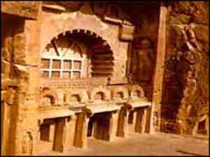
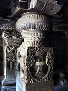
Seven Wonders Of India : Ajanta Ellora
Hidden away from view in the middle of nowhere, or so it may seem to us today, and nestled in the hills themselves, are two magical locations where the rulers of yore thought it befitting to display the artistry of their time recording for posterity stories from mythology. These caves are none other than the famous Ajanta and Ellora caves, located near the city of Aurangabad in Maharashtra. This city is all geared for tourists who flock in from around the world to see these famous caves. The richness of their imagery and the fact that they were carved between the 2nd century BC and the 8th century AD is highly impressive. It appears that while the rest of the world was in dark ages, we in this country were highly evolved in thought, word, and deed. India and Indians indeed have a past to be proud about.
It was only in the 19th century that the Ajanta group of caves, lying deep within the Sahyadri hills at Maharashtra and cut into curved mountain side above the Waghora river, were discovered. A group of British officers on a tiger hunt stumbled on these wonderous ancient works of art. They depict the story of Buddhism, spanning the period from 200 BC to 650 AD.
The Ellora caves, of which there are a total of 34, are carved into the sides of a basaltic hill 30 kolometers from Aurangabad. The finest specimens of cavetemple architecture, they boast of elaborate facades and house exquisitely adorned interiors. These structures representing the three faiths of Hinduism, Buddhism, and Jainism, were carved between the 350 AD to 700 AD. The 12 caves towards the south are Buddhist, the 17 in the center are dedicated to Hinduism, and the 5 caves to the north are Jain.
The Indian caves of Ajanta-Ellora are easily accessible by air, road, and rail from the other major Indian cities and states. Touristplacesinindia can arrange all types of transport for your comfortable journey to and in Ajanta-Ellora and also throughout the Indian state of Maharashtra.
In order to make your travel tour to Ajanta-Ellora memorable you need to choose the right kind of accommodation for you and your family or friends in Ajanta-Ellora. Aurangabad makes for a convenient base for a trip to the caves of Ajanta-Ellora. The various hotel packages in Aurangabad offer you the best of facilities.
Visit:
http://www.touristplacesinindia.com/won ... llora.html
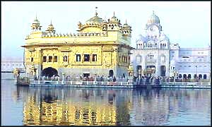
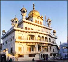
Seven Wonders Of India : Golden Temple
The Golden Temple is the ultimate Sikh pilgrimage. The Harmandir Sahib, as it is traditionally known, actually means the temple of Hari or the Supreme God. Also known as the Darbar Sahib, the stupendous, architectural phenomena is located at the city of Amritsar. The temple's exterior is gold-plated and the structure stands in the middle of a square tank. There is a causeway across the Pool of Nectar to reach the Temple. The shrine is symbolical of the doctrines of Sikhism. It also represents the magnificent strength of all the Sikhs. The amazing thing about Harmandir Sahib is that it has doorways on all four sides, meant to be open for the people of the all four castes. All over the, the Sikhs always look forward to visit to the magnificent temple and offer prayers at the Harmandir Sahib.
Golden Temple of Amritsar
The study of the art and architecture of the Golden Temple has, unfortunately, remained a subject of unconcern for art historians and critics. Even scholars of Indian temple architecture have bypassed it and references, whenever made, were mere courtesies. Fergusson considered the Golden Temple an example of the forms, which Hindu temple architecture assumed in the nineteenth century. According to the official list of buildings of interest, published by the Punjab Government in 1875, the design of the temple, as reconstructed by Ranjit Singh, was borrowed from the shrine of Saint Mian Mir, near Lahore. Louis Rousselet, writing in 1882, regarded it as a "handsome style of architecture". Major Cole described it as an adaptation of Mohammadan styles, flavoured with a good deal of Hindu tradition. Percy Brown considered it to be a product of the synthesis of Hindu and Muslim influences, combined with elaborations that imparted it an appearance of its own.
Guru Arjan Dev thought of building a central place of worship for the Sikh community. In 1588, after finalizing the design of the Darbar Sahib, he laid down the foundation of the temple himself. His followers started living in the adjacent area and the town of Ramdaspur came up. The town of Ramdaspur later came to be known as Amritsar, deriving its name from the holy pond that beautifies the area surrounding Hari Mandir. The planning to dig the holy tank or Amrit Sarovar was made by Guru Amar Das. However, the construction of the tank took place under the supervision of Baba Budha ji. The land for the site was acquired free of cost from the zamindars (landlords) of native villages. The first Sikh Maharaja Ranjit Singh made Amritsar his spiritual capital. He developed the temple further including the gilding of the embossed plates, renewing of the pietra dura and the embellishment of the ceilings with the mirror and floral designs.
Akal Takhat Sahib in Amritsar Amritsar is an institution by itself. And the Golden Temple is the cradle of Amritsar with the city growing around it nurtured by its divine sanctity. The Golden Temple stands there in simple majesty, the gilded splendor of its paneling, dome and minarets shining in the morning light, silhouetted softly in the water and etched gently across the city escape. For the Sikh community the Harmandir Sahib Gurdwara Golden Temple is the final spiritual "vision," journey's end or beginning and, for every other community too, it is a shrine to be visited.
Besides the Golden Temple there are several other Gurudwaras in India that are of great importance to the pilgrims. Another important pilgrimage site is Anandpur Sahib, where Guru Gobind Singh, the tenth Guru created the 'Khalsa' or the pure ones by baptizing them. Anandpur Sahib (in Ropar District) is one of the five Sikh takhts or thrones. Sikhs from all over India visit this holy site especially on the occasion of Holla Mohalla which coincides with the last day of Holi and marks the festival's finale. On this day, the Gurudwara Keshgarh is filled with people and colour as men in bright turbans and women in gaily-colored salwar kameezs try to live up to Guru Gobind Singh Ji's vision of Holi.
Visit:
http://www.touristplacesinindia.com/won ... llora.html
Seven Wonders Of India : Mahabodhi Temple
The life of Gautam Buddha, the founder of Buddhism, is associated with the small town of Bodhgaya. It is one of the four holiest cities of Buddhist faith. The Mahabodhi temple is the main attraction of this town and is located near the spot where Lord Buddha attained spiritual enlightenment. Bodhgaya is not only an important Buddhist pilgrim center, but it is also an important center for the study of Buddhism.
Mahabodhi Temple and other monasteries are the major attractions in Bodhgaya. Places associated with the life and times of Lord Buddha are located inside the Mahabodhi complex including the Bodhi Tree and a pond where according to legends, Lord Buddha mediated for few days.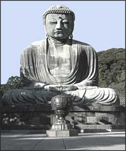
You need to choose just the right kind of accommodation for you and your family or friends in Bodhgaya. The various hotel packages in Bodhgaya offer the best of facilities. The well-furnished rooms make excellent place to stay in Bodhgaya.
Visit:
http://www.touristplacesinindia.com/won ... emple.html
Seven Wonders Of India : Hampi
Hampi is located in the central part of the state of Karnataka, in the southern part of India. It is 353 km from Bangalore, and 13 km from Hospet. It is located on top of a rugged terrain and is 467 m above sea level. Tungabhadra River flows through Hampi. It has a tropical climate with hot summers (April-June), and cool winters (October-February). It experiences the southwestern monsoon rains from June to August.
Hampi is famous for its ruins belonging to the erstwhile medieval Hindu kingdom of Vijaynagar and it is declared a World Heritage site. The main tourist spots in Hampi can be divided into two broad areas: the Hampi Bazaar area and the Royal center near Kamalapuram.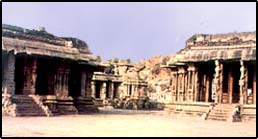
The 15th-century Virupaksha Temple is located in the Hampi Bazaar area. It is one of the oldest monuments of the town. The top of the temple rises about 50 m from the ground and the main shrine is dedicated to Virupaksha, a form of Lord Shiva. Hemakuta Hill, south of the Virupaksha temple, contains early ruins, Jain temples and a monolithic sculpture of Lord Narasimha, a form of Lord Vishnu.
Planning a trip to Hampi? Enjoys the best of tour packages. For many tourists, Hampi is famous for its ruins belonging to the erstwhile medieval Hindu kingdom of Vijaynagar and it is declared a World Heritage site.
Visit:
http://www.touristplacesinindia.com/won ... hampi.html
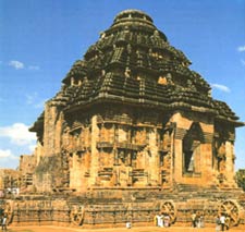
Seven Wonders Of India : Konark - Sun Temple
About 65 km from Bhubaneswar, near the sacred city of Puri, is the great Sun Temple of Konark. The temple dedicated to the Sun God or Surya is a masterpiece of Orissa's medieval architecture and has been designated a United Nations (UNESCO) World Heritage Site.
The massive structure of the temple, now in ruins, sits in solitary splendour surrounded by the drifting sands. The entire temple has been designed in the shape of a chariot carrying the Sun God across the heavens. The huge intricate wheels of the chariot, which are carved around the base of the temple, are the major attractions of the temple. The spokes of these wheels serve as sundials, and the shadows formed by these can give the precise time of the day. The pyramidal roof of the temple, made of sandstone, soars over 30 m in height. Like the temples at Khajuraho, the Sun Temple at Konark is also covered with erotic sculptures
Situated at a distance of 64 km from Bhubaneswar, the magnificent Sun Temple is the prime attraction of Konark. Probably constructed by Narashimhadev I in the mid-13th century, the temple is dedicated to Surya, the Sun God, and is designed in the form of his huge chariot.
In the medieval period, when the temple was on the shore (the shoreline has receded more than 3 km today), it was used as a navigational aid by the European sailors on their way to Calcutta. They used to call it the "Black Pagoda" to distinguish it from the "White temple"-the Jagannath Temple at Puri. An earlier Surya temple existed in Konark as long back as the 9th century but most of the existing structure dates from the 13th century
Visit:
http://www.touristplacesinindia.com/won ... emple.html

Natural Wonders Of India : Silent Valley National Park
Located in the Kundali Hills of the Western Ghats, the Silent Valley National Park holds a valuable treasure of rare plants and herbs. The Park is rich in its wildlife, and elephants, lion-tailed macaques and tigers are the most common residents of this park. Perhaps, nowhere else can you also find such a representative collection of peninsular mammals, over a 100 species of butterflies and 400 species of moths and other fauna like the ceylon frog moth, great Indian hornbill, the Nilgiri laughing thrush and the lion-tailed macaque.
The Park has a vibrant history. In late 1970's, the Kerala State Electricity Board decided to construct a Hydel Power Project in this region. But when in 1980, this region was declared a National Park, the area of the Hydel Project was not included. Protests led to the Board changing its decision.Consequently in 1984, the Park was again re-notified with the Project area included. Finally in 1986, the Park was declared the core area in the Nilgiri Biosphere Reserve.
The river Kunthi descends from the Nilgiri hills, at an altitude of 2000 mts above sea level and traverses the entire length of the valley and rushes down to the plains through the deep forest. This river never turns brown and is always crystal clear, perennial and wild.
Though smaller in size in comparison to the other national parks in India, what makes it different is the sylvan environment the region has, along with its high altitude peaks and several rivers that run through it. The Park also houses hundreds of species of butterflies and moths along with birds. Another valuable attribute of this Park is its reserve of rare medicinal plants and herbs.
Visit:
http://www.makemytrip.com/indiabest/ind ... -parks.htm

Natural Wonders Of India : The Neral Junction-Matheran Narrow Gauge Railway
A masterpiece of engineering, the line climbs steeply into the Western Ghats.
The road up to Matheran can be seen in the background.
Visit:
http://dmorg.org/indiabike/01bombaytobi ... b0118.html

Konkan Railway:
*
For most of us (of the Konkan), getting away meant a long, jolting bus-ride—until 1998, when the Konkan Rail made its maiden run from Mumbai to Mangalore. Ratnagiri went from being a 12-hour bus ride to a smooth five hours. Travel time to Goa was cut by nine hours. And all this through towering rocky hills, iron-rich red earth, emerald rice paddies and endless groves of mango. Overnight, the pleasure of getting to the Konkan became at least partly the getting there.
*
I caught the Nizamuddin-Trivandrum Rajdhani Express which traverses the entire Konkan stretch, and went on a joyride through a stunningly picturesque region of forbidding ghats, criss-crossed by shimmering creeks and estuaries, on my way to Ratnagiri.
Leaving Nizamuddin station at 11 am, we were in Konkan territory once the Rajdhani crossed the Vaitarna river in upper Maharashtra, at around 8 pm. When you reach Vasai Road—for all purposes the first Konkan stop—at 9.30 pm ...
*
We passed from Mumbai to Pen overnight ... I woke up fresh at 7:00 am as the Konkan experience began. Between Chiplun and Rajapur Road came the first of a series of breathtaking views as we charged through dark tunnels and emerged over viaducts spanning rivers nearly 60 feet below. Looking east I was treated to the forested slopes of the ghats and the deep valleys in which the sweet red rice of the Konkan grows. To the west, waterfalls tumbled down the Sahyadris, beyond which lay patchwork fields running down to the sea. A Malayali government servant on his way home to Cochin, watching me run back and forth between doors as he brushed his teeth, was of the opinion that there was nothing worth looking at in the Konkan, which could not even begin to be compared to Malabar. For scenery, he said, or for that matter for anything, I should go all the way down to Trivandrum, where even the waves pound the beaches of Kerala to a natural rhythm, unlike the crude sounds of the Arabian sea slapping rocks on Konkan beaches. I had work to do, however, in Ratnagiri which we would reach shortly, and promised I would return to the debate about superior wave sounds another time. Fifteen minutes before Ratnagiri, we passed through the 6.6-km long Kharbude tunnel—the longest tunnel on the KR line.
*
We were in Ratnagiri by 9:30 am. It’s the First City of the Konkan— district headquarters, and a fantastic base for excursions to Malvan, Ganapatipule and the sea fort of Sindhudurg, to name a few. Ratnagiri has the distinction of being home to the Alphonso (the best mango on earth), Dawood Ibrahim (India’s most wanted gangster), and the forgotten tomb of King Thibaw (of Burma), enclosed in a housing colony. I rushed through my work and made a beeline for the seaside town of Ganapatipule, a 45-minute drive away, in time to catch the sunset.
*
I was back on the train the next morning, heading to Goa, and here’s a tip for travellers on the Rajdhani. To get a sense of the triumph of technology over terrain that marks the Konkan rail, stand at the train door as you leave Ratnagiri. Just after the train leaves the station, it takes a 180 degree turn, climbs an embankment, charges through a deep cut in the mountain, over a viaduct and into another tunnel, emerging over the spectacular Panval viaduct, the tallest in all of Asia. If you have the courage to stick your head out and peer beyond the railing, you’ll glimpse the silver river far below.
*
So seduced was I by the beauty of the coast over the next few hours that I decided that Goa could wait one more day. I left the Rajdhani at Sawantwadi and headed to Amboli, a hill station astride the Sahyadris. Amboli is full of spots from which to gaze at hills, and waterfalls falling all the way to the valley.
*
Goa is a three-hour bus ride from Sawantwadi. If Ratnagiri is the Queen of the Konkan, Goa is surely the jewel in its crown. And the jewel in Goa’s crown, its claim to the title ‘Rome of the East’, is the sacred relic of Saint Francis Xavier.
*
Konkan Railways operates some 20 trains up and down the scenic Konkan coast. The longest of the lot is the super-fast Trivandrum Rajdhani. This train is now the fastest way to get to Kerala from Delhi by train, lopping several hours off the previous best option, the Kerala Express. Another long-haul fast train is the Netravati Express (Trivandrum-Kurla).
Visit:
http://www.outlooktraveller.com/aspscri ... d=7&page=1
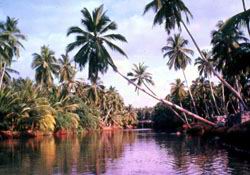
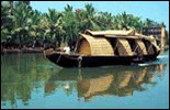
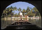
Green Green Kerala:
* Backwaters of Kerala
A journey exploring the delights of the Green Gateway of India also fondly called "God's Own Country"
Visit:
http://www.india-travel-services.com/kerala-tours.htm
http://www.india-travel-services.com/ke ... waters.htm

Karwar:
With gentle waves, miles of golden sand, a tranquil ambience and acres of emerald foliage, Karwar has all the makings of a perfect holiday destination. The captivating landscape is ringed with rugged hill ranges, thick woods and mysteriously deep valleys. This paradise inspired the great Indian muse Rabindranath Tagore to pen his first play. Since then, this little town has continued to inspire all its visitors.The Sadashivgad Hill Fort with a Durga Temple, the unique octagonal church, the 300-year old Venkatrama Temple with ochre paintings and the Naganatha Temple, where an ant hill is worshipped, are sure to make a lasting impression. Devbagh is the most enchanting of the five islands along the Karwar coast. Visits to Anjidev Island are restricted. The time to visit Karwar is from September to mid May.
Visit:
http://www.indiahotelsandresorts.com/ka ... index.html
Dharwar:
DHARWAR, a town and district of British India, in the southern division of Bombay. The town has a station on the Southern Mahratta (Later, S / SC / SW ) Railway. The population in 1901 was 31,279. It has several ginning factories and a cotton-mill; two high schools, one maintained by the Government and the other by the Basel German Mission.
The DISTRICT OF DHARWAR has an area of 4602 sq. m. In the north and north-east are great plains of black soil, favorable to cotton-growing; in the south and west are successive ranges of low hills, with flat fertile valleys between them. The whole district lies high and has no large rivers.
In 1901 the population was 1,113,298, showing an increase of 6% in the decade. The most influential classes of the community are Brahmans and Lingayats. The Lingayats number 436,968, or 46% of the Hindu population; they worship the symbol of Siva, and males and females both carry this emblem about their person in a silver case. The principal crops are millets, pulse and cotton. The centres of the cotton trade are Hubli and Gadag, junctions on the Southern Mahratta railway, which traverses the district in several directions.
The early history of the territory comprised within the district of Dharwar has been to a certain extent reconstructed from the inscription slabs and memorial stones which abound there. From these it is clear that the country fell in turn under the sway of the various dynasties that ruled in the Deccan, memorials of the Chalukyan dynasty, whether temples or inscriptions, being especially abundant. In the i4th century the district was first overrun by the Mahommedajis, after which it was annexed to the newly established Hindu kingdom of Vijayanagar, an official of which named Dhar Rao, according to local tradition, built the fort at Dharwar town in 1403. After the defeat of the king of Vijayanagar at Talikot (1565), Dharwar was for a few years practically independent under its Hindu governor; but in 1573 the fort was captured by the sultan of Bijapur, and Dharwar was annexed to his dominions. In 1685 the fort was taken by the emperor Aurangzeb, and Dharwar, on the break-up of the Mogul empire, fell under the sway of the peshwa of Poona. In 1764 the province was overrun by Hyder Ali of Mysore, who in 1778 captured the fort of Dharwar. This was retaken in 1791 by the Mahrattas. On the final overthrow of the peshwa ~fl 1817, Dharwar was incorporated with the territory of the East India Company.
It Was Part of Hyderabad Karnataka, alongwith Gulbarga / Bijapur / Bidar ... Now A Seat Of Learning & Gateway To Beautiful Uttara Kannad ("North Canara") Area of Karnataka ... Hubli - Dharwar Promises To Be The Bright Jewel in the New Industrial IT Rich India ... Besides Gifting World Class Cricketers!
*
428 kms from Bangalore, is Dharwar, known for its scenic beauty and pleasnat weather. Dharwar is also a famous educational Centre. Dotting this town are magnificent monuments.
The All Saints Church, Basel Mission Church and the Roman Catholic Church are some of lthe important churches. The temples dedicated to Hanuman, Dattatreya, Durgadevi and Panduranga are a must see. Dharwar is famous for lits mouthwatering 'Pedas'.
Visit:
http://www.1911encyclopedia.com/D/DH/DHARWAR.htm
http://www.ourkarnataka.com/states/dharwar.htm

Our Himalayan Twin Wonders ... A Recent Pilgrim's Report! : Kedarnath & Badrinath
*
We returned Home last night after a gruelling 6-day trip to Uttaranchal visiting Badrinath (10500 ft ) and Kedarnath (12000 ft ). After a train ride to Haridwar, we travelled in a good old Ambassador with a local driver who knew all the finer details of the roads, temples, etc. Quite a bit of the mountain road was under repairs, which meant stoppages and passing narrowly by steep gorges. It was hot till about 3000 ft and started to cool after that. We could see snow clad hills at Badri and Kedar.
The trip to Kedarnath merits a special description by itself. We travelled directly from Badrinath, starting at 6 am, stopping at Joshimath for a couple of hours, and reaching a place called Gauri Kund (about 6500 ft high) by 7pm. It's a small place, crammed with buses and other vehicles; so many that quite a few have to go back 5 km to find a parking place. The road itself is narrow.
**
We stayed in a lodge for the night and started next morning on horses for the 14 km trek to Kedarnath. The path is 12-15 feet wide, paved with stones, with steps as well as inclined parts. You climb over 5000 feet over this stretch, in 4.5 hours, with a half hour break. But the problem is that the path is shared by horses, doliwallas ( 4 people carrying one person on a simple 'palki' ) as well as pedestrians, all going up as well as down. The path is strewn with horse urine and shit, mixed with mud. The walkers are pushed by the others, and are forced to walk through this muck at several places. The occassional shower makes it worse. The horse ride itself is no joy. The travel down on horses was worse, with every part of the body being shaken up. We were really relieved when it was all over.
The stay at Kedarnath was however memorable. It was a simple accomodation, but we could see snow capped mountains all round. there were hordes of people and long lines ... we could have darshan and puja the same afternoon. I had another darshan of the linga ( a large stone shaped more like the hump of a buffalo) in the evening. Greatest of all, we had one more darshan on the morning of 24th May before we started back. You are allowed to touch the linga. To be at one of India's most hallowed places ( one of the 12 jyotirlingas ) on the 60th birthday was a special experience. It was perhaps the closest you can get to Kailasam, if you believe in it. I was certainly feeling thankful to the Lord for helping us do this entire yatra.
On the whole, I will not recommend a trip to Kedarnath to any one not fully fit. There is the cold, the reduced oxygen level (about which I was worried, but we got away with a mild headache), the somewhat primitive facilities, and of course the unpleasant climbing up and down. You are some what better off with the dolis, but the bottleneck at Gauri Kund remains. I was repeatedly wondering how Americans or Europeans would have developed the infrastructure at such places.
Visit:
http://www.badrinath-kedarnath.org/
Our Himalayan Twin Wonders ... Addenda : Kedarnath & Badrinath
*
Well I would recommend a trip to badrinath to all the adventure and nature lovers. Its one of the most beautiful places. On the way from Haridwar till Badrinath there are a plenty of places to stop and enjoy. Specially places like Auli, sangam.
The best part is the Vasudhara waterfalls which is a waterfall between mountains and is about a 5 to 6 km walk in mountains from Mana. Mana is the last village on Indian border and is 3 KMs from badrinath.
It's a difficult trip to reach vasudhara waterfalls but when you reach there you will realize that it was worth taking all that pain.
**
I second it.
And do not miss the prayags and staying in the wooden guest rooms,
road side tea stalls, filing empty "aqua fina" bottles with "cleaner water" from the water streams from the rock slide. A peep from the window down the steep crevice, unbelievable flora etc. And if you dare a dip in Alakananda or Mandakini anywhere. (Please do not be brave at any time until you reach Haridwar).
Good luck - this is adventure and fun beyond what you can get in sanitizied switzerland or scotland.
***
Great to see your travelogue. It reminded me of our trip 15 years
ago. Obviously we walked up and down the mountain.
People do not know that it is less stressful to walk up and down than riding a horse or a doli. Yes the path was not always clean, but it is great to hear that they have left nature and adventure in tact without laying a tar road and having VIPs zooming in in their BMW.
In Kedarnath the sparse oxygen creates a problem at the temple.
Come down 2000 ft, you will be fine. In Badrinath, a head bath in
the sulphur spring can put you in a tizzy. And ofcouse in Manikaran you cannot even touch the hot spring water, it will scald the skin.
Visit:
http://www.badrinath-kedarnath.org/

The Dark Green Tunnel : 1983
*
This is the first of a series of fantasies for young children -- as well as young-hearted adults -- under the series title of The Mesmerian Annals. Written in a modern setting but in the style of The Chronicles of Narnia by C.S. Lewis (to whose memory the book is dedicated), this book tells the story of the young twins, Barnaby and Lara, who, while on a trip into the remote regions of the Florida Everglades by boat with their slightly older cousin, stumble accidentally into a parallel world called Mesmeria, where there are witches and warlocks, evil kings and good princes, strange and dangerous creatures; a land locked in a struggle between good and evil, with the deadly King Thorkin and his chief henchman, the evil sorcerer, Warp, having the upper hand until Lara and Barnaby join forces against them to help restore the throne to its rightful occupant, Prince Daw. An enchanting visit to a remarkable and sometimes scary world filled with amazing adventures for the twins. Where the series by C.S. Lewis was a religious allegory, this series could more accurately be termed an ecological allegory. Hardbound and beautifully illustrated by David Wiesner. Originally published in hardcover in 1983 by Little, Brown & Co., Boston, Mass. Having gone out of print, the book has recently been reprinted in a softcover books-on-demand format by iUniverse.com, Lincoln, NE, and may be ordered by calling their toll-free number, 1-877-823-9235.
Visit:
http://www.allaneck.com/b_dark-green.html
Jodhpur-Jaisalmer
A travelogue on the mesmerising deserts of Jodhpur-Jaisalmer and its rich history, culture and tradition:
Nature perhaps demanded more from valiant men. And so, the Rathore rulers of the former kingdom of Marwar emerged triumphant in the hazardous desert conditions on account of their sheer hardiness!
Jodhpur- the former capital of Marwar state was founded in 1459 by Rao Jodha, who claimed descent from Lord Rama. The massive fort, Mehrangarh came first and around it grew the city of Jodhpur protected by a high stone wall with seven gates and countless bastions. Today, the city has grown to become the second largest city of Rajasthan while still maintaining it's medieval character.
Jodhpur stands sentinel to the Thar desert and is a gateway to the wonderland of sand dunes and shrubs, rocky terrain and thorny trees. ...
Visit:
http://www.viewsunplugged.com/VU/200203 ... lmer.shtml
Travel In Luxury ... *****
Deccan Odyssey : Mumbai - Ratnagiri - Nagari - Sawantwadi - Karmali - Madgaon - Pune - Aurangabad - Nasik - Mumbai
***** Travelled by Bus From Mumbai / Mahad / Ratnagar To Goa & Back!
Sawantwadi : In Maharashtra ... Gateway To Goa ... Green Green Forest Lands ... Cries / Sightings of Wild Cad / Panther / Leopard / TIGER
... Grand Green Entrance To Goa
Visit:
http://images.google.co.in/imgres?imgur ... D%26sa%3DG
Thunder Wonder ... *****
The Wonder of Thunder
... we rarely hear or read about an electrical storm's audio accompaniment: thunder.
# The meteorological science behind thunder and its rumbles is complex, but the basics are easy to understand.To begin with, note that lightning bolts have no curves along their paths. All sections of a zigzagging bolt are straight and they connect at sharp angles. During thunderstorms, lightning bolts may occur inside a cloud, between a cloud and the earth's surface, between two clouds, or even between a cloud and the surrounding air. Within storm clouds, moisture, warm and cold temperatures and fast moving air all combine to create a strong electric charge. Once that charge builds to several million volts (enough to cause the electrical breakdown of air), those megavolts force a tremendous electric current to flow to or from a region with an opposing charge.
The path of this current can be many miles long, but it is no wider than a garden hose. The flow of current instantly heats surrounding air to an extremely high temperature. The gaseous expansion caused by that incredible heat then collapses, creating cylindrical shock waves along the entire bolt path. These waves are transmitted initially as one clap of thunder.
But here's the mystery: The shock waves that cause thunder last only a fraction of a second, so why does the booming carry on for up to several seconds? Echoes off ground surfaces, buildings and nearby mountains are one reason, but the main factor behind thunder's longevity is the extreme length of the lightning bolt.
Lightning races through the sky at more than 60,000 miles per second, but sound travels through air at only one-fifth of a mile per second. So, if a long vertical flash is one mile away, the first thunder arrives in five seconds. The sounds continues to arrive from higher and higher up the bolt, and may last several seconds or more.
In similar fashion, the speed of sound is also partly responsible for the rumbling we hear, due to refraction - the bending of sound waves. Although its change in speed is not great, sound travels faster in warm air than in cold, increasing in speed by about one foot per second with each degree Fahrenheit rise in temperature. These small changes are important because air temperature varies significantly across the atmosphere, and especially during storms.
Atmospheric temperature change can also be abrupt, as when incoming warm air slides over existing cold air. When this happens and a sound wave in cold air approaches the warm air at an angle, those portions of wave front that enter the warm air first will speed up, thereby rotating the entire front a few degrees and changing the wave's travel direction. Conversely, sound waves entering cold air from warm air at an angle will slow the wave and bend it in opposite manner. Bear in mind, even a gradual change in temperature can cause sound waves to bend. In some cases, rising sound waves can keep bending and, depending on rise-angle and other conditions, head back to Earth.
When sound waves radiate from a lightning bolt, vertical changes in air temperature cause extensive bending. Horizontal temperature changes, due mainly to air pockets and columns of rising or falling air, also bend sound waves. A11 this simultaneous refraction results in myriad crisscrossing sound waves.
Sound waves are also influenced by destructive interference. When similar waves are superimposed, their vibrations oppose or support each other, which results in a haphazard mixture of cancelled and reinforced sounds. Therefore, when lightning is a few miles away, we hear throbbing variations of sound - the rumble of thunder.
- Walter S. Andariese
Visit:
http://www.motherearthnews.com/menarch/ ... -092-1.jpg
http://www.motherearthnews.com/library/ ... of_Thunder
Meir Gitlis in his lab: From the age of 10, I began inventing things and haven't stopped.
Israeli Inventor's Latest Wonder: An Earthquake Warning System January 02, 2005
The Earthquake Alert
An Israeli invention that provides early warning for earthquakes could enable every homeowner to rest easier. The size of a shoebox and costing $170, the sensor device is the brainchild of Meir Gitlis, who has been inventing things since... well, he was a child.
The world received an horrendous reminder last week about the power of earthquakes. The 8.9 tremor that struck off Indonesia's shore has claimed over 120,000 victims, almost all from the tidal waves it caused. Gitlis doesn't claim that his early warning system could have made much of a difference, but argues that any advance warning would have been better than none.
The Earthquake Alert - developed by Gitlis's R&D company Avtipus, and marketed by EQ Technologies - is based on the seismological principles of global earthquake monitoring systems. It contains an array of pendulums that naturally react to vibrations and send a signal through an electronic circuit to a chip. The chip analyzes the frequency and determines whether it's a sonic boom, a bomb - or an earthquake. Having that advance warning, according to Gitlis, can mean the difference between life and death.
"An earthquake is like lightning and thunder," Gitlis told ISRAEL21c. "First comes the primary waves which run through the ground very quickly. The instrument can sense the primary wave which occurs tens of seconds before the secondary wave, which is the destructive wave. The pre-warning of a half minute enables people to find cover."
According to Gitlis, Israel's tallest office building - The Azrieli Towers in Tel Aviv - has installed the Earthquake Alert in its elevators. In the event of a quake, the system halts the elevator at the nearest floor, giving people a chance to get out and protect themselves.
Researchers at the State University of New York at Buffalo recently tested the sensor and deemed it reliable and credible, backing Gitlis's claim that the sensor doesn't react to sonic booms or other false alarms. According to SUNY Buffalo's National Center for Earthquake Engineering Research (NCEER) director, Prof. A. Reinhorn, "the pre-warning devices provided a consistent response under the simulated ground motions, regardless of whether this was repetitive ground motion or another earthquake. No false alarm which could have involved spontaneous triggering or detection within the background noise (pretest noise) occurred."
The Earthquake Alert is just the latest manifestation of Gitlis's obsession to create something new, a lifelong passion he plunges into freely at Avtipus ...
Visit:
http://www.israel21c.org/bin/en.jsp?enD ... ne=Health&
The Tirumalai Nayak Palace ... Wonder of the South
Down the Corridors of Time: The Tirumalai Nayak Palace ... A Wonder of the South
IN its heyday, Tirumalai Nayak's Palace at Madurai was considered to be one of the wonders of the South.
A Jesuit priest who summed up his life's achievements, soon after his death in l659 has this to say about him:
"His reign was rendered illustrious by works of royal magnificence. Among these are the pagoda of Madura, several public buildings, and above all, the royal palace, the colossal proportions and astonishing boldness of which recall the ancient monuments of Thebes. He loved and protected the Christian religion, the excellence of which he recognized, but he never had the courage to accept the consequences of his conviction. The chief obstacle to his conversion came from his 200 wives, of whom the most distinguished were burnt upon his pyre." ...
Visit:
http://www.hinduonnet.com/thehindu/thsc ... /&prd=mag&
Look 42 degrees up and around to see a rainbow
Wonder Rainbow ... : Rainbow reflected in Rabbitkettle Lake, NWT, CanadaEach rainbow you see is unique to you and centered on your eyes so all rainbows form a circle centered on a point marked by the shadow of your head (called the antisolar point). To see light from the top of a rainbow, you look up at an angle of 42 degrees. To see light from the sides of the arc, you look over 42 degrees. To see light from the bottom of the rainbow, you look down 42 degrees. Of course, if the ground is in the way, you won't see the bottom of the circular bow.
The necessary conditions for seeing a rainbow is: water droplets in those directions and the Sun lighting those drops. Usually the ground gets in the way and blocks water and light from reaching the lower part of the circle. See second figure. But not always. Zooming along in an airplane, you can see a whole circle rainbow because there are sun-lit drops everywhere. Looking at your garden hose spray you can see most of the rainbow circle but not the bottom part shaded by your body.
However, a mountain won't work for a full circle. "On a mountain peak-no matter how high... droplets on the part of the circle below the antisolar point will be shaded by the mountain."
Visit:
http://www.wonderquest.com/2002-03-06-rainbow.jpg
Sight The Mile-High Rock Called "Grimming"! ...
Visit:
http://www.joseph-marx.org/images/austr ... 003-06.jpg
Users browsing this forum: No registered users and 1 guest
{{todos[0].text}}


